


Introduction
Imagine looking up at the sky and seeing a blur of feathers dive at speeds over 200 miles per hour. That is the peregrine falcon, one of nature’s most impressive hunters. But have you ever wondered where these birds go when they fly out of sight? For centuries, this was a mystery. Today, thanks to incredible advancements in technology, falcon tracking has opened a window into the secret lives of these raptors.
This article explores the fascinating world of monitoring birds of prey. We aren’t just talking about old-fashioned bird watching with binoculars. We are diving deep into satellite telemetry, radio signals, and the vital conservation work that relies on accurate data. Whether you are a wildlife enthusiast, a student of biology, or just curious about how scientists keep tabs on animals, you will find valuable insights here.
Key Takeaways:
- Understand the evolution from traditional banding to modern satellite telemetry.
- Learn how falcon tracking helps scientists protect endangered species.
- Discover the different types of technology used, including GPS and radio transmitters.
- Find out the challenges researchers face when attaching devices to wild birds.
What Is Falcon Tracking?
Falcon tracking is the scientific process of monitoring the movements, behaviors, and habitats of falcons. While people have admired these birds for thousands of years—falconry is actually one of the oldest sports in history—our ability to follow them across continents is relatively new. In the past, if a falcon flew away, it was gone. Now, we can see exactly where it sleeps, hunts, and migrates.
At its core, this practice is about gathering data. Scientists want to know survival rates, migration routes, and breeding success. By using falcon tracking methods, researchers can build a map of a bird’s life. This data is crucial because many raptor populations have faced steep declines due to pesticides like DDT and habitat loss. Knowing where they go helps us protect the places they need most.
The History of Tracking Birds of Prey
Before we had satellites and microchips, bird tracking was a very low-tech affair. It started with bird banding (or ringing). Scientists would place a small metal band with a unique ID number on a falcon’s leg. This method had a major flaw: to get any data, you had to catch the bird again or find it after it had died. The recovery rate was incredibly low, often less than 1%.
The game changed in the 1960s with the invention of radio telemetry. This allowed researchers to follow a signal, almost like a game of “hot and cold.” However, you still had to be relatively close to the bird to pick up the “beep-beep” of the signal. Falcon tracking took its biggest leap forward with the introduction of satellite telemetry in the 1980s. Suddenly, a bird could be in South America while the researcher sat at a computer in New York, watching its progress in real-time.
From Metal Bands to Microchips
The transition from simple metal bands to sophisticated microchips represents a massive shift in ornithology. Early bands only told us point A and point B—where the bird was banded and where it was found. It told us nothing about the journey in between. Did the bird fly straight there? Did it stop for weeks at a specific lake?
Modern falcon tracking fills in these blanks. We now use devices that can record altitude, speed, and even temperature. Some advanced trackers use GSM networks (cell phone towers) to send data back, which is cheaper and often more detailed than satellite data. This evolution means we can understand the daily decisions a falcon makes, rather than just its final destination.
Why Is Falcon Tracking Important for Conservation?
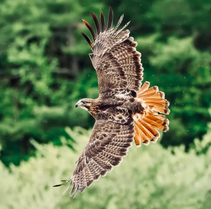
Conservation is arguably the most critical application of falcon tracking. Many falcon species, such as the Peregrine Falcon and the Gyrfalcon, travel thousands of miles during migration. They cross international borders, fly over oceans, and navigate through dangerous urban environments. Without tracking data, we wouldn’t know which specific areas are critical for their survival.
For example, tracking might reveal that a specific group of falcons stops at one particular wetland to rest and refuel during migration. If developers plan to drain that wetland to build a shopping mall, scientists can use the tracking data to prove the site’s ecological importance. Falcon tracking provides the hard evidence needed to lobby for habitat protection laws and environmental regulations.
Identifying Threats in Real-Time
Another major benefit is identifying causes of death. In the past, if a population of falcons dropped, we could only guess why. Now, if a tracked bird stops moving, researchers can go to the exact GPS coordinates to investigate. They might find the bird was electrocuted by a power line, poisoned by rodenticides, or shot illegally.
This immediate feedback loop allows conservationists to address threats quickly. If multiple birds die near a specific power line, utility companies can be contacted to retrofit the poles with bird-safe equipment. This proactive approach, driven by falcon tracking data, saves countless birds from preventable deaths.
How Satellite Telemetry Works
Satellite telemetry is the gold standard for long-distance falcon tracking. It involves attaching a Platform Transmitter Terminal (PTT) to the bird. This device sends signals to satellites orbiting the earth, such as the Argos system. The satellites calculate the bird’s location and relay that information back to processing centers on Earth.
The beauty of this system is its global reach. It doesn’t matter if the falcon is flying over the Sahara Desert or the Arctic tundra; as long as there is a line of sight to the sky, the tag can transmit. Researchers can log into a web portal and download the coordinates, visualizing the bird’s path on a map. This technology has revolutionized our understanding of global migration patterns.
The Role of Solar Power
One of the biggest challenges in falcon tracking is battery life. You cannot exactly call a falcon down to swap out double-A batteries. To solve this, most modern satellite transmitters are solar-powered. They have tiny solar panels on their backs that recharge the battery whenever the bird is in sunlight.
This innovation allows transmitters to last for years, sometimes for the entire life of the bird. It enables “duty cycles,” where the transmitter turns on for a few hours to send data and then turns off to save power. Solar power ensures that we get a long-term dataset, which is essential for understanding trends over multiple years and seasons.
Different Types of Tracking Devices
Not all trackers are created equal. The choice of device depends on the bird’s size, the study’s goals, and the budget.
GPS-GSM Trackers
These use the Global Positioning System (GPS) to determine location and then use mobile phone networks (GSM) to send the data.
- Pros: Very high accuracy, cheaper data costs, can transmit huge amounts of data.
- Cons: Only works where there is cell phone coverage. If a falcon goes deep into the wilderness, data is stored until it flies back into range.
Argos Satellite Transmitters
These send data directly to satellites.
- Pros: Works anywhere in the world, regardless of cell towers.
- Cons: Expensive hardware and expensive data subscription fees. Location accuracy is sometimes lower than GPS.
Radio Telemetry (VHF)
The “old school” method using a handheld antenna.
- Pros: Very cheap, lightweight, battery lasts a long time.
- Cons: You must be close to the bird to track it. Labor-intensive.
How Scientists Attach Trackers to Falcons
Attaching a device to a wild animal requires immense care and skill. The safety of the bird is the number one priority. If a falcon tracking device is too heavy or attached incorrectly, it can hinder the bird’s ability to hunt or fly, essentially sentencing it to death.
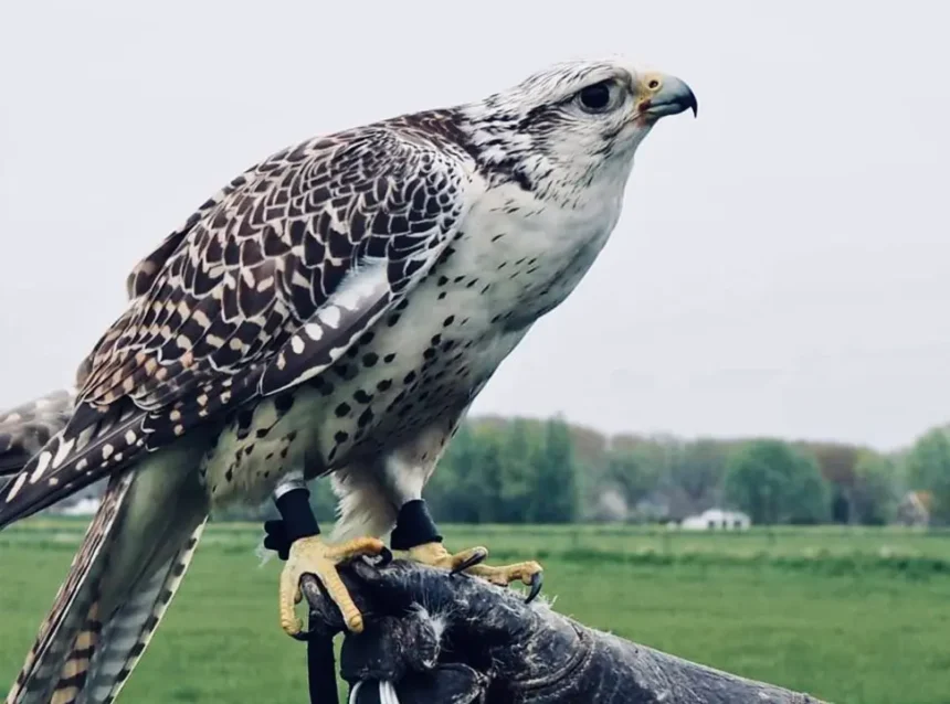
There is a strict rule in biology generally called the “3% rule” (sometimes up to 5%). The tracker should not weigh more than 3% of the bird’s total body weight. For a large female Peregrine Falcon, this allows for a decent-sized transmitter. For a small Kestrel, the technology must be incredibly tiny.
The Backpack Harness Method
The most common method for attaching a solar-powered satellite transmitter is the backpack harness. This harness is usually made of Teflon ribbon, which is smooth, durable, and resistant to UV light. It loops around the bird’s wings and sits comfortably on its back, much like a hiker wearing a backpack.
The harness is custom-fitted to each individual bird. It needs to be loose enough to allow full range of motion for flying and breathing, but tight enough that it doesn’t slip or chafe. Once fitted, the bird preens its feathers over the straps, making the device aerodynamic. Most falcons get used to the sensation very quickly and return to normal behavior within hours.
Analyzing the Data: What We Learn
Once the data starts pouring in, the real work begins. The raw data from falcon tracking is just a list of dates, times, and coordinates. Scientists use specialized software (like GIS – Geographic Information Systems) to turn this into visual maps and statistical models.
We learn incredible details about flight speeds and altitudes. For instance, data has shown that migrating falcons often use thermal updrafts—columns of rising warm air—to gain altitude without flapping, saving precious energy. We can see exactly how weather systems affect their travel. Do they hunker down during a storm? Do they use tailwinds to speed up? The data tells all.
Understanding Home Ranges
A “home range” is the area a bird uses for its daily activities like hunting and resting. Falcon tracking allows biologists to draw precise boundaries around these areas. This is vital for urban planning. If we know a pair of falcons uses a specific park and the surrounding three miles for hunting, city planners can ensure that development doesn’t destroy that critical zone.
Challenges and Limitations of Falcon Tracking
Despite the high-tech wizardry, falcon tracking is not without its headaches. The technology is expensive. A single satellite transmitter can cost between $3,000 and $5,000, not including the monthly data fees. This limits how many birds can be studied at once.
There is also the risk of equipment failure. Sometimes a transmitter just stops working. Did the battery die? Did the electronics fail? Or did the bird die? Without recovering the unit, researchers often never know. Furthermore, trapping wild falcons to attach the devices is difficult and requires special permits and expert handling skills to ensure no harm comes to the animal.
Table: Comparison of Falcon Tracking Methods
Here is a quick breakdown of the different technologies used in the field.
|
Feature |
Radio Telemetry (VHF) |
Satellite (Argos) |
GPS-GSM (Cellular) |
|---|---|---|---|
|
Global Range |
No (Local only) |
Yes (Global) |
Limited (Cell coverage) |
|
Accuracy |
Low (Triangulation) |
Medium |
Very High |
|
Cost |
Low |
High |
Medium |
|
Data Retrieval |
Manual (Receiver) |
Automatic (Satellite) |
Automatic (Cell Tower) |
|
Battery Life |
Long |
Variable (Solar helps) |
Variable (Solar helps) |
|
Best Use |
Local studies |
Migration studies |
High-res local/regional |
The Ethics of Tracking Wildlife
Is it right to attach electronic devices to wild animals? This is a question ethical review boards ask constantly. The consensus is that the benefits of falcon tracking for the species as a whole outweigh the minor inconvenience to the individual bird, provided strict protocols are followed.
Researchers must undergo rigorous training. They have to prove that the data they collect will actually contribute to science and conservation. If a study is just for curiosity without a clear conservation goal, it is rarely approved. The goal is always to have a net positive impact on the falcon population.
Falcon Tracking in Urban Environments
Falcons, particularly Peregrines, have adapted surprisingly well to city life. Skyscrapers resemble the high cliffs they naturally nest on, and cities are full of pigeons (a favorite snack). Falcon tracking in cities presents unique challenges and opportunities.
GPS signals can sometimes bounce off tall buildings, creating “multipath errors” where the data shows the bird inside a building rather than on top of it. However, the abundance of cell towers makes GSM tracking very effective in urban areas. Tracking urban falcons has taught us how they navigate the “concrete canyons” and avoid hazards like glass windows and traffic.
The Role of Citizen Science
In cities, falcon tracking often involves the public. Bird watchers and photographers often spot banded or tagged birds and report them to websites. While this isn’t “tracking” in the electronic sense, this observational data validates the electronic data. If a satellite says a bird is on the Chrysler Building, and a photographer snaps a picture of it there, the data is confirmed.
Interestingly, some tech enthusiasts and wildlife centers now livestream data or nest cams. You can read more about how technology intersects with daily life and nature on sites like Silicon Valley Time, where digital trends often overlap with real-world applications.
The Future of Tracking Technology
What comes next for falcon tracking? The devices are getting smaller, lighter, and smarter. We are moving toward “bio-logging,” where devices measure the bird’s heart rate, wing beat frequency, and body temperature. This will tell us not just where the bird is, but how it is feeling. Is it stressed? Is it working hard?
We are also seeing better integration of AI. Artificial Intelligence can analyze the movement patterns to automatically classify behavior. Instead of a human looking at dots and guessing “the bird is hunting,” the AI will analyze the speed and turning radius to say “Hunting attempt: Successful.”
How You Can Get Involved
You don’t need a PhD to help with falcon tracking and conservation. Many organizations rely on donations to purchase expensive transmitters. You can “adopt” a tracked falcon, often receiving updates on its location.
Additionally, reporting sightings of banded birds is a huge help. If you have a good camera or binoculars and spot a falcon with a band or an antenna, note the location, time, and any numbers you can read. Submit this info to the Bird Banding Laboratory or local wildlife agencies. Your observation becomes a permanent part of that bird’s scientific record.
Frequently Asked Questions (FAQ)
1. Does the tracker hurt the falcon?
No, when attached correctly by professionals, the tracker does not hurt the bird. It is designed to fit like a comfortable backpack. The weight is carefully calculated to ensure it does not impede flying or hunting.
2. How long does a falcon tracking device last?
It depends on the battery and the power source. Solar-powered units can last for several years, potentially the bird’s entire life. Battery-only units might only last a few months or a year.
3. Can I buy a tracker and tag a falcon myself?
Absolutely not. Falcons are protected by federal and international laws (like the Migratory Bird Treaty Act in the US). Capturing, handling, or tagging them requires strict federal permits and years of training.
4. How much does a satellite transmitter cost?
They are expensive. A high-quality GPS satellite transmitter can cost anywhere from $3,000 to $5,000, plus annual data subscription fees which can run nearly $1,000 a year.
5. What happens if the harness breaks?
Most harnesses are designed with a “weak link” or made of material that will eventually degrade over many years, allowing the transmitter to fall off so the bird isn’t stuck with it forever.
Conclusion
The science of falcon tracking has revolutionized our understanding of these apex predators. From the early days of metal bands to today’s solar-powered GPS transmitters communicating with satellites, we have unveiled the mysteries of migration, survival, and behavior. This technology is not just cool gadgetry; it is a vital tool for conservation. It allows us to identify threats, protect critical habitats, and ensure that future generations can continue to watch these magnificent birds soar.
As technology continues to shrink and improve, our window into the world of falcons will only get clearer. We are moving from simply watching dots on a map to understanding the physiology and minute-by-minute decisions of wild animals. It is a thrilling time for biology, and every piece of data helps secure a future for the rulers of the sky.
For more information on general topics, you can always check a reliable encyclopedia. Find a link from https://www.wikipedia.org/ related to this keyword ” falcon tracking ” and add it here: You can read more about the technology behind these studies on the Wikipedia page for Animal migration tracking.